The Great Society Subway:
A History of the Washington Metro,
by Zachary M. Schrag
d.w.rowlands [at] gmail.com
Growing up in the DC suburbs, my family didn't ride Metro often, but we did ride it whenever we travelled into the District, mostly to visit museums. It was a major part of my understanding of the District, and it had a sort of unique status for me. When my family travelled to other cities---largely to visit relatives---we never went anywhere with a subway, or when we did (Baltimore, for example), we didn't ride it and I never knew it existed. As a result, I am not sure I really entirely grasped that other cities had subways; I certainly didn't realize that DC's was relatively unusual among American subway systems.
My first real experience with another subway system was the even newer Metro in Los Angeles, which I rode occasionally as an undergraduate at Caltech. It wasn't until grad school, when I rode the pre-war systems in Boston, New York, and Chicago, that I began to understand how different the Washington Metro is. It was also around that time that I first read The Great Society Subway: A History of the Washington Metro, by Zachary M. Schrag. The Great Society Subway is a very detailed history of the construction of Metrorail and the social and political forces that led to and shaped it. I really enjoyed the book and would recommend it to anyone interested in the Twentieth-Century history of Washington, DC, or the history of rapid transit in the United States in general.
The following essay is a summary of the book that I wrote during my most recent re-reading of it. More information and photos can be found on the author's website.
The City, 1791-1955
Like most American cities, Washington, DC developed a streetcar system in the Nineteenth Century. Like most such systems, it started to lose ridership to cars between the World Wars, but the increase in Washington's population during World War II, combined with gasoline and tire rationing helped it become more profitable and build up cash reserves. There was even consideration given by the DC government for a thirty-five million dollar project to build a system of streetcar subways beneath a number of downtown streets. However, these plans were never acted on, except for the construction of a streetcar tunnel and station beneath Dupont Circle.
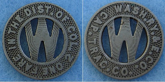
Capital Traction, the private company that had run DC's streetcar network since 1933, had kept its dividends low by stockpiling the profits from its World War II boom years as a cash reserve. However, in 1949, a controlling interest in the company was purchased by a group of investors who were more interested in maximizing their income by paying large dividends---larger than the company's yearly profit---from this cash reserve. By 1955, most of the reserve was gone, and the new management's policies had angered the company's labor unions. An extended strike that year eventually led the DC government to have Capital Transit's franchise cancelled and a new investor was found to run transit in the city. As a condition of the new franchise, the federally-appointed DC government insisted that the streetcar network be closed by 1963 and replaced with buses, because they believed that streetcars were inappropriate for a modern city and got in the way of cars.
The Plans, 1955-1965

Planning for a potential rapid transit system in Washington, DC began in 1955 with an Eisenhower Administration project called the Mass Transportation Survey intended to plan a highway and transit system that would ensure that the city had sufficient transportation for commuters in 1980. The group responsible for the project contained both rail transit and highway advocates, but it decided to assume that the large-scale urban freeway network being proposed by the Maryland, Virginia, and DC highway departments and expected to be funded under the 1956 Interstate Highway Act would be built in full, and only to consider transit as a possible addition. The traffic models used were also quite questionable, as they were based on the dual assumptions that no non-freeway road would be improved in the future and that no freeway would ever become congested. In 1959, the Mass Transportation Survey finally presented its report to Eisenhower, consisting of a large highway network, eight highway-based express bus routes (without bus lanes), and a thirty-mile downtown rapid rail network that would be about half underground.
In 1960, Congress created the National Capital Transportation Agency, headed by Kennedy appointee C. Darwin Stolzenbach, to refine the MTS's recommendations into a workable system. Stolzenbach, an opponent of urban freeways, proposed a much larger, 83-mile rapid transit system and a diminished freeway system (though still one more extensive than what was eventually built.) His extensive transit plan was killed by concerns over its cost, opposition to the idea of cancelling highways (which the Federal government was already committed to contribute a larger fraction of the expenses for than rail transit), and his tendency to make enemies of people who disagreed with his plans. However, it is interesting to note its similarities to what was eventually built: it includes a U-shaped line similar to the actual course of the Red Line, although with a branch from the western side of the U serving the Mid-City area currently served by the north-of-downtown portion of the Green and Yellow lines. This U-shaped line also serves Rockville from its eastern branch, along the CSX Brunswick Line rail right of way to the northwest, with its western branch terminating just north of Bethesda. A branch off the eastern branch of the U-shaped line appears to follow the current northern portion of the Green Line into Prince George's County. Meanwhile, a downtown east-west line appears to split at Rosslyn to follow the current routes of the Orange and Blue lines in Virginia, while its eastern portion turns south and shows some similarity to the southern portion of the Green Line. The Maryland end of the Orange Line is replaced with commuter rail along the Northeast Corridor, the only commuter rail contemplated in the plan.
In 1965, President Johnson fired Stolzenbach and replaced him with Walter McCarter, the recently-retired head of the Chicago Transit Authority. Stolzenbach's departure managed to dissipate the NCTA's bad reputation, and McCarter managed to convince Congress to approve a much-reduced "bobtail plan" consisting of twenty-five miles of track in Washington and Arlington (about half of it underground). This plan included one east-west line downtown, with two branches to the east (along the current eastern branch of the Red Line to Silver Spring and the eastern branch of the and Blue Line to Benning Road) and three branches to the west (along the current western branch of the Blue Line to Pentagon City, the current western branch of the Red Line to Van Ness, and a branch from the Van Ness line to the Mid-City.
The Stations, 1965-1967
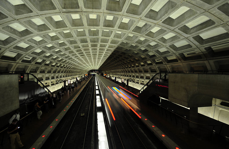
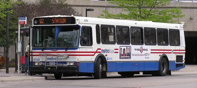
The design of the underground stations is possibly the most recognizable part of the DC Metro. Until recently, the only above-ground signs of the underground stations downtown were monolithic black pillars that could easily be missed in the visual noise of a busy street. They have now been joined by glass canopies over what were originally open-air escalators, but even these canopies have been designed to mirror the vault walls and ceilings of the underground stations.
These stations, which are both unusually uniform for a network of Metro's size, and notably different from the designs of other underground subway stations in the United States, were largely the product of pressure from the Commission of Fine Arts, a board of seven "well-qualified judges of the fine arts" appointed by the President to review and make recommendations on the designs of public buildings in Washington, DC. The architects, led by Harry Weese, hired by the National Capital Transportation Agency to design stations were interested in designing stations that felt like public buildings and had "a certain dignity and even elegance". They were also very interested in avoiding the feel of pre-World War II American subways, particularly New York's, which had developed a reputation for ugliness, dirtiness, and crime. Although Weese had originally wanted vaulted ceilings with skylights and no mezzanines, he was convinced by the NCTA's engineers that cut-and-cover stations ought to have flat ceilings to maximize space, and that mezzanines and deeper stations would make it easier to avoid interfering with the tangle of utilities already in place below DC's streets. Vaulted ceilings would be retained for deep-bore stations, some of which would also have exposed rock walls.
Weese and the NCTA proposed their design to the CFA, only to find that the Commission, with its sole focus on aesthetics, rejected their practical concerns. The Commission wanted all underground stations to be as identical as possible---regardless of engineering differences---to provide a continuity of experience for riders. They also pushed strongly for vaults and wanted a more "indoors" feel to the stations. However, the final vault design settled on created an open feeling, and Weese stood fast to his insistence that platform fixtures be built with a solidity that made them feel like outdoor streets.
The Region, 1966-1967
In 1965, Congress had approved a basic rapid-transit system for DC to be built by the National Capital Transportation Agency. The NCTA was a Federal agency, which Congress saw as appropriate for a system that was largely only intended to serve DC (Three stations were in Virginia, at Rosslyn, the Pentagon, and Pentagon City, and two were in Maryland, in Silver Spring.), which still lacked home rule and was governed by a Federally-appointed government. However, transit was not a District-specific problem, particularly since many of the commuters it was intended to serve would be coming from suburbs in Maryland and Virginia.
Historically, transit lines in Virgina, DC, and Maryland were largely run by different companies with often-conflicting schedules. In 1955, a Joint Transportation Commission had been established by the Maryland and Virginia legislators and DC Board of Commissioners to negotiate a regulatory regime for the various transit services in the area. The commission proposed an interstate compact, similar to the Port Authority of New York and New Jersey---which had been established in 1931---be created to regulate the region's transit. In 1960, the same act of Congress that authorized the NCTA, also authorized the interstate compact creating the Washington Metropolitan Area Transit Commission to regulate private transit---largely bus lines---in the Washington metropolitan area. It also authorized a second interstate compact to operate the new rapid-transit system, but only if the compact could be agreed upon before NCTA completed the system.
NCTA was largely run by supporters of DC home rule and opponents of freeways who distrusted suburbanites and the idea of an interstate compact to run their rapid transit system. At the same time, the Joint Transportation Commission distrusted the powers that the NCTA had as a Federal agency, and wanted more local control for the transit system through an interstate compact. Although it had originally been hoped that the interstate compact might have broader powers to control road as well as transit construction, the JTC wanted to avoid getting involved in the NCTA's fight over highway construction, so it was decided that the compact would be limited to setting up a transit agency. By 1966, a compact establishing the Washington Metropolitan Area Transit Authority had been pushed through the state legislatures and Congress and WMATA was born. The new agency was governed by a six-person board with two members each from Maryland, Virginia, and DC, and would be responsible only for operating a rapid transit system, while buses would remain in private hands.
The establishment of an interstate compact with two-thirds of its governing board from the suburbs to design the new rapid transit system required changes to the planned network. The suburban jurisdictions wanted longer extensions of lines into the suburbs, and the single downtown trunk line in the Congressionally-approved plan would quickly become overcrowded by the increased ridership this would produce. Furthermore, the number of branches coming off the main line was already fairly excessive, and would result in tight scheduling to avoid back-ups. By 1967, the NCTA and WMATA had already concluded that a second downtown trunk line---what would become the Orange/Blue/Silver downtown segment---was needed, and that the branch from Dupont Circle into Columbia Heights, intended to serve low-income neighborhoods, should be cut. However, this cut was agreed to only with the understanding that a third trunk line, running north-south through the Mid-City neighborhoods that had been served by the spur, would be included in the final system.
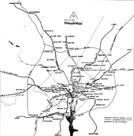
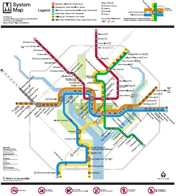
Plans for suburban extensions were based in part on the considerations of where cheaper right-of-ways could be found---rail lines and freeways were preferred---and on the belief that forty-five minutes was the maximum commute time that suburbanites would find acceptable. By 1968, the ninety-eight mile "Adopted Regional System" had been approved, consisting of three downtown trunk lines, three Virginia branches with two river crossings, four branches into Prince George's County, MD, and two into Montgomery County, MD. The 1968 ARS is quite similar to what was eventually built, although it includes several stations that were never built, or were eventually built in somewhat different locations than originally planned.
The Bridge, 1966-1971

Given that the original proposals for rapid transit in Washington, DC were conceived in part with the intent that they could serve as substitutes for the network of urban freeways under discussion, it is not entirely surprising that Metro construction became a hostage in the fight over the construction of urban freeways in DC. In the early 1960's, community groups in the District were beginning to organize against two specific projects: the construction of the Northeast Freeway along the B&O Railroad right-of-way that the eastern branch of the Red Line would eventually be built along and the construction of a bridge over the Potomac at a group of small islets called the "Three Sisters" that would carry a branch of I-66 into Georgetown and necessitate the construction of the Inner Loop Freeway through Georgetown and downtown to keep from swamping the local streets with the traffic it would carry.
Although the anti-freeway activists were able to convince the National Capital Planning Commission to cancel the Three Sisters Bridge in 1966, this turned out to merely be the beginning of the fight. William Natcher, a conservative congressman from Kentucky and chair of the House Subcommittee on District of Columbia Appropriations, took personal offense at the District deciding not to build highways that Congress had authorized as part of the Interstate Highway System. Natcher couldn't directly force the District to build freeways it didn't want, but since the District could not spend any money without a Congressional appropriation, he was in a position to strong-arm the city and anti-freeway activists by denying District funds for Metro until the District changed its mind and build the bridge. Since bonds couldn't be sold and Federal transit funds couldn't be appropriated with the District's funding in limbo, Natcher could effectively put Metro on hold until he was satisfied that the bridge would be built.
In April 1966, Natcher announced that he would block the District's funding for Metro unless the Three Sisters bridge was built, and by May, the NCPC had reversed its decision and decided to build the bridge. However, Natcher was unwilling to release the funds until enough construction occurred that he was convinced that the bridge would not be cancelled again. WMATA initially continued with planning work, hoping that the situation would be resolved by the planned February 1968 groundbreaking, at which point construction funds would need to have been secured. Anti-highway agitation continued however, and construction on Metro was not able to start in 1968. Finally, in August of 1969, under the pressure of threats that WMATA would have to disband for lack of funding, the DC government was---with the aid of President Nixon---able to convince Natcher that the city would build the Three Sisters Bridge and associated freeways. In September, Natcher allowed Congress to release the funds and, in December, ground was finally broken at Judiciary Square.
Anti-freeway activism continued, and in February 1970, the District decided to cancel some of the freeways, though not the Three Sisters Bridge. That August, Natcher blocked Metro funds from being included in the District's appropriations, forcing Metro construction to slow and extreme measures to be taken to maintain funding. The matter was not resolved until December 1971, when---encouraged by the Maryland and Virginia delegations, whose constituents wanted Metro built and had also begun to turn against the freeways that would need to be built to feed into the urban freeways to be built in the district---the House voted to overrule the Appropriations Committee and Natcher and approve the District's Metro funds.
The Builders, 1972-1976
The initial phases of construction of Metro were spearheaded by Jackson Graham, WMATA's General Manager from March 1967 though November 1975. Graham was a retired general in the US Army Corps of Engineers. Graham, who had served as Director of Civil Works for the Corps, was an admirer of Robert Moses as well as Patton and MacArthur and had a somewhat dictatorial focus on "getting things done". However, unlike Moses, he was a skilled manager of people as well as money and power, and inspired intense loyalty from his staff.
Despite Graham's deep knowledge of and tightly-held control over the construction of Metro, his plans were occasionally stymied by resistance from beyond his dominion. The National Park Service, which controls much of the land in the District, was a major source of resistance and was responsible for several changes to the layout of the final system. The National Park Service, used to fighting against highway incursions into parkland and the damming of rivers and draining of swamps, saw Metro as just one more incursion to be resisted at all costs. Two results of this were seen along the Red Line at Farragut Square and at its crossing of Rock Creek. The Rock Creek crossing had originally been intended as a bridge over the deep Rock Creek gorge. The National Park Service forbade this as an unacceptable interference with the views down the gorge---although it is crossed by a number of road bridges---and insisted that a deep tunnel be built. In order to tunnel under the gorge, the Dupont Circle and Woodley Park stations had to be built especially deep, making escalator rides to the surface much longer than would otherwise have been necessary and preventing a stop from being built in Adams Morgan.
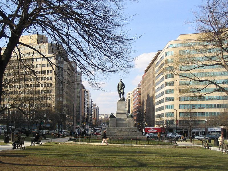
Even more unfortunate was the fight over Farragut Square. The two east-west tunnels through downtown Washington cross twice: in the "old downtown" at Metro Center and nearly a mile away at Farragut Square, a small, one-block park with a statue of Admiral David Farragut in the "new downtown". Transfer stations were originally planned in both locations. However, construction of the Farragut Square transfer station would have required digging up the park and temporarily moving the statue, which the National Park Service considered unacceptable. Because construction under the park was forbidden, two separate stations without the possibility of a transfer had to be built a few hundred feet apart on opposite sides of the square.
On the other hand, NIMBY opposition cannot actually be blamed for the absence of a station in Georgetown. While it is true that there was neighborhood opposition to Metro in Georgetown, a Metro station there had never actually been seriously considered. Downtown Georgetown is very close to the Potomac, and a station there would have needed to be very deep, as well as requiring expensive tunneling under private property. Furthermore, Metro's planners did not see Georgetown as an important destination to serve: the system was primarily intended to serve rush-hour commuters by connecting dense housing and suburban parking lots with downtown office buildings. Georgetown, lacking both dense housing and dense office buildings, did not attract many commuters and its location right on the Potomac meant that nearly half the land within walking distance of a potential Georgetown station would be under water. Ironically, the one station that was cancelled due to neighborhood opposition was not in rich, white Georgetown but in the poor African-American neighborhood near RFK Stadium, where a planned Orange-and-Blue Line station at Oklahoma Avenue was cancelled.
Another fight that Graham lost, with more positive results, was over the inclusion of elevators in Metro stations. Harry Weese's original designs for Metro stations were intended to take into account the needs of the disabled. Platform edges were lined with visually distinctive material to make it easier for visually impaired passengers to avoid falling onto the tracks---although it was not until several decades later that tiles with warning bumps would be added for the completely blind---and escalators were provided everywhere that stairs were. However, Weese left elevators out of the stations, convinced that they would disrupt travel patterns, provide places for criminals to lurk, and serve little purpose because wheelchair users were unlikely to ride the system. In December 1969, however, the House Subcommittee on Public Buildings and Grounds had hearings in which disability advocates argued forcefully that escalators would provide a serious barrier to many passengers. The result of the hearing was a recommendation that "inclinators"---escalators that traveled at an angle in a shaft along with escalators---be built in all stations. After a consideration of the costs of developing this new technology, though, Graham decided to oppose them as well as more traditional elevators.
In a rather bizarre attempt to prove that elevators were unnecessary, Graham took a film crew to Dulles Airport, where the escalators were the same design as those planned for Metro, and had himself filmed ascending and descending the escalators while wearing a number of braces and crutches and then while riding a wheelchair while facing upward. However, the film only helped to convince disability advocates that WMATA was not serious about accommodations for wheelchair users, leading them to sue the Authority under the Architectural Barriers Act of 1968, which required wheelchair access in all new buildings financed with Federal funds. In June 1973, a Federal judge ruled that no Metro station without elevators would be allowed to open, and elevators had to be rapidly included in plans for stations that were already under construction.
The Money, 1972-1980
By modern standards, it is hardly surprising that Metro's fare income is not sufficient to pay its operating costs, and that continual subsidies are needed to keep it running: this is true of essentially every transit system in the United States. However, when the system was originally proposed, it was expected that an operational system would be able to pay back some of its construction costs, as well as paying for its own operations, from farebox revenue. Construction costs were significantly higher than had been expected, due to higher bids from contractors than had been expected, changes made to the design of the system, and the combination of construction delays and the significant inflation of the late 1960's and 1970's.
That it was politically impossible to raise fairs to keep up with inflation was made clear after WMATA's 1973 takeover of the area's bus network. The original interstate compact creating WMATA had forbidden it from operating buses, and had even required it to contract out operation of its rail network. However, by the late 1960's, DC Transit, the company that ran bus routes in the District and Montgomery County, was entering a financial meltdown and, in spring 1970, the District government pushed for changes to the compact, finally approved in October 1971, to allow WMATA to operate buses and rail transit, and to acquire private transit companies if necessary. After unsuccessful negotiations to buy the failing companies, in January 1973, WMATA seized DC Transit and Virginia's WV&M bus lines under eminent domain. Three weeks later, the two remaining major private bus companies, Virginia's AB&W and Prince George's County's WMA, were bought by WMATA after their owners requested a buy-out to avoid having to compete with a public bus network.
The creation of Metrobus forced WMATA to learn to run operations and deal with having passengers earlier than expected. It also forced them to deal with the backlog of deferred maintenance and poor labor relations that the management of the failing DC Transit had left behind. Although WMATA was able to improve the bus system and stabilize ridership by pumping money into it, it became clear that only about half of the bus network's expenses could be paid for by fares. This threatened the logic of depending on fare revenue to pay back construction costs for Metrorail, just as it was becoming clear how much more expensive than expected construction was becoming. Truncating the system to only those lines already under construction was considered, although it was clear that this would only reduce ridership and fare recovery.
In 1975, the first elected DC City Council convened. The newly-elected body suggested that cost overruns in Metro construction could be paid for by taking advantage of a 1973 law that allowed local jurisdictions to cancel unwanted freeways and use the Federal funds intended for them for transit, albeit with a 20% local contribution instead of the 10% local contribution required for roads. Doing so would provide funding for the full system, as well as ensuring that the District's stalled freeway projects would not be built. The Ford administration agreed, with the complication that relying on national transit aid meant that Metro was now required to comply with other Federal rules for transit projects. In particular, the Ford Administration's Urban Mass Transit Administration wanted new construction to be incremental, with single lines built and operated before construction began on the next segment, and demanded "alternatives analyses" be completed for the lines that had not yet been built. This meant that the entire Mid-City Line and its extensions into Prince George's County, as well as the Orange Line from Ballston to Vienna and the Blue Line from King Street to two terminals in Franconia and Springfield would need to be delayed for reconsideration. In the end, however, the changes from the alternatives analysis were minor: the southern end of the Green Line was rerouted from Branch Avenue to Rosecroft Racetrack (only to be reversed by a Court order), the Springfield terminal was eliminated after failing an environmental review, leaving a single Blue Line terminus at Franconia, and discussions of moving the Vienna terminal of the Orange Line to Tyson's Corner went nowhere.
The District
The 1968 riots after Martin Luther King's assassination helped to push businesses out of downtowns throughout the US by reinforcing the idea that they were dangerous wastelands in the minds of rich, white, suburban Americans. In Washington, the riots damaged the image of the city's already-dying old downtown between the White House and Capitol, which was loosing stores and offices to the suburbs and the new downtown that had developed to the northwest of the White House. The city declared the entire old downtown an urban renewal area in 1969, although there was pushback from residents and business owners who were scared that the complete demolition and rebuilding of Southwest DC would be repeated in their neighborhood. As the Redevelopment Land Agency tried to decide how the area could be revitalized, they focused on the coming Metro stations, including two of the system's three downtown transfer stations, that were to be built in the old downtown. There were also plans to pedestrianize many of the streets in downtown: while the few test pedestrian malls were eventually returned to cars, the city's streets never suffered the extreme automobilization that many American downtowns suffered in the period, largely because redevelopment efforts focused so heavily on Metro and pedestrian access.
The 1968 riots also led to changes to the Mid-City segment of the Green Line. The original plans had the line running straight up 7th St NW and Georgia Avenue from Mount Vernon Square to Petworth with two intermediate stations. After the riots destroyed much of the Mid-City's 14th St commercial strip, the city government pushed for---and paid for---a western jog in the line and an extra station at U St and 12th St as well as a further-west Columbia Heights station on 14th St. The jog increased the number of people in Mid-City conveniently served by Metro, but it also delayed the construction of the Green Line---already planned to be built last---even further. The Green Line's Mid-City corridor did not finally open until January 2001, after all of the suburban branches included in the Adopted Regional System had been open for years or decades.
The Suburbs
Downtown DC was not the only area to develop walkable, transit-oriented density in the vicinity of Metro lines. Perhaps more impressive than the revitalization of old, pre-automobile neighborhoods in the District was the development of several walkable, transit-oriented neighborhoods in suburban areas that had never had them before. Arlington County, Virginia and Montgomery County, Maryland did the best jobs of encouraging this sort of development along their Metro lines, while Prince George's County, Maryland and Fairfax County, Virginia did the worst job of doing so. Early plans for Metro's suburban lines had largely focused on routing them along existing rail corridors or in the medians of freeways to minimize construction costs. While this strategy does reduce the cost of construction and right-of-way acquisition, it also tends to develop stations in largely unwalkable areas. The Arlington and Montgomery County governments both came to adopt the idea, based on Scandinavian models, that transit stations should be built as the centers of mixed-use developments with retail, office, and residential buildings, even as zoning rules in much of the country forbade such developments, especially in suburban areas.
The Orange Line through northern Arlington County and central Fairfax County was originally planned to run along the median of I-66 from its terminal near the City of Fairfax to the Potomac River, a route that would largely take it through neighborhoods of single-family houses. By 1966, however, the Arlington County government had pushed for the line to be moved south to a subway under Wilson Boulevard, an arterial road and former streetcar corridor that the county's development plan had slated for a relatively dense commercial strip. With the help of General Services Administration preferences for locating Federal agencies near Metro stations, the county was successful in developing the corridor as an employment center as well as a retail district. The Rosslyn neighborhood, across the Potomac from Georgetown, is now a downtown with the tallest buildings in the Washington area (since DC's height restrictions forbid skyscrapers within the District) and an urban feel. The rest of the corridor has developed in a relatively transit-oriented and walkable manner as well, even Ballston, at the western end of the corridor, which in the 1950's was a car-oriented shopping district notable for having the world's largest parking garage.
In Montgomery County, the main uncertainty about the route of the Metro lines was whether the eastern branch of the Red Line should head northwest to Rockville from Silver Spring along the B&O railroad tracks it followed through DC, or whether it should head due north to Wheaton. In the latter case, the western branch would run north from Bethesda to Rockville; in the former it would be terminated just north of Bethesda. In the end, the county government settled on the more expensive plan of having both branches run north along arterial road corridors---Georgia Avenue in the east, and Rockville Pike in the west---rather than having a short branch to Bethesda and a longer one along the B&O railroad tracks. The county government then successfully pushed for dense mixed-use development in both Bethesda and Silver Spring and, more recently, in Rockville.
When The Great Society Subway was published in 2006, the Silver Line to Tyson's Corner and Dulles Airport had just been approved. Given that Tyson's is now the clear downtown of Fairfax County---if a very auto-oriented downtown---it is unfortunate that the chance to route the Orange Line there instead of along I-66 was missed when it was built decades earlier. Unlike Arlington County, Fairfax County had no real development planning in the 1960's, and the development of Tyson's happened largely organically. Without plans for a dense retail and commercial center, the county opted for the cheapest construction option of building the Orange Line in the median of I-66. Furthermore, the independent City of Fairfax---incorporated cities in Virginia are county-level entities and not part of the counties that surround them---was a member of the WMATA compact and wanted the orange line to run west to Vienna, where it would be a short drive from the city.
The Riders
Impressively, given the record of post-World War II rapid transit construction in the United States, especially in cities like Washington that were not major metropolitan centers in the Nineteenth Century, Metro has grown to be the second-highest-ridership rapid transit system in the US after the New York Subway. This is in part due to the fact that it covers such a large area---it has the second-most track as well---although it has two-and-a-half times the ridership of BART, the next-most-ridden post-War subway, although Metro has only thirteen miles of track more than BART. The facts that Metro serves the downtown core with three trunk lines, creating a network of stations rather than a single corridor, and that transit-oriented multi-use developments were planned along several of the system's suburban branches were major contributors to this as well. While Metro does not quite live up to the luxurious, space-age dreams of its planners and architects in the 1960's, it has managed to become an essential part of transportation in the Washington region, as well as a very distinct transit system, not quite like anything else in the US.