The Populations of Large US Cities Over Time
d.w.rowlands [at] gmail.com
New York, Philadelphia, and Boston have been among the larger cities in the US since the Revolution, although Boston and Philadelphia have lost ground to newer cities. Los Angeles, now the second-largest city in the country, didn't make the top ten until around 1900, a half-century after California was annexed, while New Orleans was already the sixth largest city in the country when it was purchased from France during the Jefferson administration, but now doesn't make the top ten. While it is well known that the relative populations of cities have changed with time, I thought it would be interesting to go through Census data to find out exactly how they have changed, and which cities were the largest during each census.
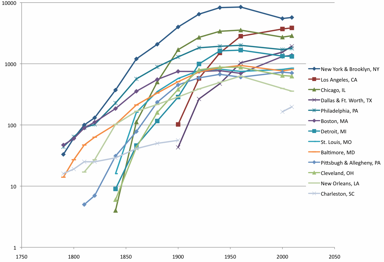
Population (in thousands) of large US cities as a function of time. Cities are shown if they were in the top five cities by population in any US census.
I started by collecting population data from the Census for almost every city that had ever been among the top 20 in population. (I excluded several that were in the bottom of the top twenty in the first two censuses, but immediately fell into obscurity.) Although I started using every census, I quickly decided to switch to only censuses in years that were multiples of twenty, since this decreased the needed data-copying and didn't seem likely to introduce any really serious problems. When I tried to produce graphs with this data, they were absurdly crowded and hard to read, so I decided to only graph the thirteen cities that had, at some point, been among the five largest in the United States.
That disposed of the issue of how I was going to define "major". "City", on the other hand, proved harder to define. First of all, though, my goal here is to compare cities as social and economic entities, not political units. So it seemed natural that I should combine the two canonical American examples of "twin" cities: Minneapolis-St. Paul and Dallas-Ft. Worth as single cities.
I also identified four other cases of things that ought to qualify as "twin" cities and be treated as a single city. The most obvious is New York-Brooklyn. For decades before they merged in 1898, the cities of New York and Brooklyn--separated only by the East River--were among the four largest in the country. A similar, but less-known, case is Allegheny, which merged with Pittsburgh, its neighbor across its namesake river, in 1907. In the later years of its existence, Allegheny was a city fully a third the size of Pittsburgh, large enough that it would be hard to justify not including it. I also decided that San Francisco and Oakland, separated by the slightly wider San Francisco Bay, but with a similar ratio of populations, ought to be treated as a pair of "twin" cities.
I also treated Washington, DC specially, because of its unusual history. Part of the reason that George Washington selected the location he did for the District of Columbia is that he wanted it to contain the twin port towns of Alexandria, Virginia and Georgetown, Maryland, which were located on opposite banks of the Potomac a couple of miles apart. They were fairly large by the Colonial standards, and similar in size--Alexandria had just twice the population of Georgetown. When the District of Columbia was established, the new city of Washington was founded for the capital on the same bank of the Potomac as Georgetown, but downriver in the direction of Alexandria. By the 1800 census, these "triplet" cities had similar populations (three thousand each in Washington and Georgetown and five thousand in Alexandria). I treated these three cities as one until Georgetown and then Alexandria fell off the bottom of the census list of population data for the largest hundred cities in US. Later, when Arlington, Virginia, which consists of the part of Virginia's former contribution to DC that wasn't within the city limits of Alexandria, came up on the list, I added it to Washington's population as well.
Another issue, though, is that the boundary between a city and its suburbs is fairly arbitrary. By population within the city limits, Columbus is the largest city in Ohio, even though many more people live in the areas around Cleveland and Cincinnati. This is because Cleveland and Cincinnati are old cities that haven't expanded their city limits as cars and suburbanization have led many people to live further out from downtown, while Columbus is a newer city that has had a policy of aggressively annexing its suburbs by refusing to sell water from its municipal water system to suburbs that don't agree to be annexed.
The Census currently deals with this problem by defining "Metropolitan Statistical Areas" or "MSA"s, collections of counties that are meant to approximate a city and its suburbs. However, they have only been doing this for the last few decades. They claim that, before 1950, this mattered less because metropolitan areas were more concentrated, with the majority of their populations living within the city limits, and that there was less of a discrepancy between metropolitan areas in terms of the fractions of their population that lived in suburbs. Since I didn't really have a choice, I used city populations through the 1960 census. I did, however, notice that five cities--New York-Brooklyn, Philadelphia, Boston, Providence, and Los Angeles had, at certain times, suburbs or close neighbors that later became suburbs in the top fifty cities by population in the country. I decided that these suburbs should be added to the cities' populations in the years that the suburbs were in the top fifty.
Finally, I decided to use MSA data for 2000 and 2009, since it was easily available on Wikipedia. I would have used it for 1980 as well, but it was much harder to get it out of the Census website, and I was lazy. However, switching to MSA data for the last two points on the graph would make every city's population seem to jump unreasonably, since MSAs have much larger populations than their core cities. To correct for this, I divided the MSA data by the average ratio of MSA-to-city population for the cities listed in 2009.
My data sources for this project were the Census's list of the populations of the hundred largest cities in the United States from 1790 to 1990 and Wikipedia's table of US Metropolitan Statistical Areas. I also posted the data I used as a comma-separated value file.
More recently, I came across the following animation that shows a map of the top ten US cities by population in each census, though using slightly different criteria: it only considers population within the city limits in a given year, which sometimes includes cities such as Northern Liberties, PA and Brooklyn, NY that have since been annexed by other cities on the list.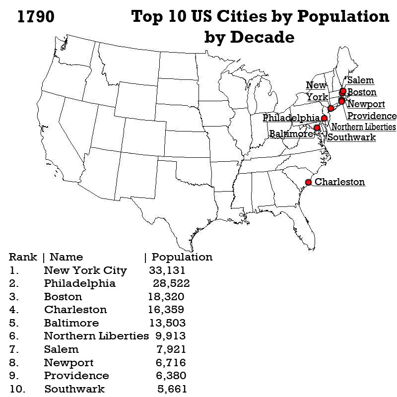
An animation I found online that shows the top ten US cities by population in each census, using somewhat different standards than I used for my analysis.