A Brief History of the T
d.w.rowlands [at] gmail.com
The following essay on the history of the T---the light rail and rapid transit lines that make up Boston's urban rail transit network---was assembled from the notes for a class I taught for the MIT Educational Studies Program in August 2014. An additional useful reference on the history of the T is this series of historical maps of the T by Alexander Rapp.
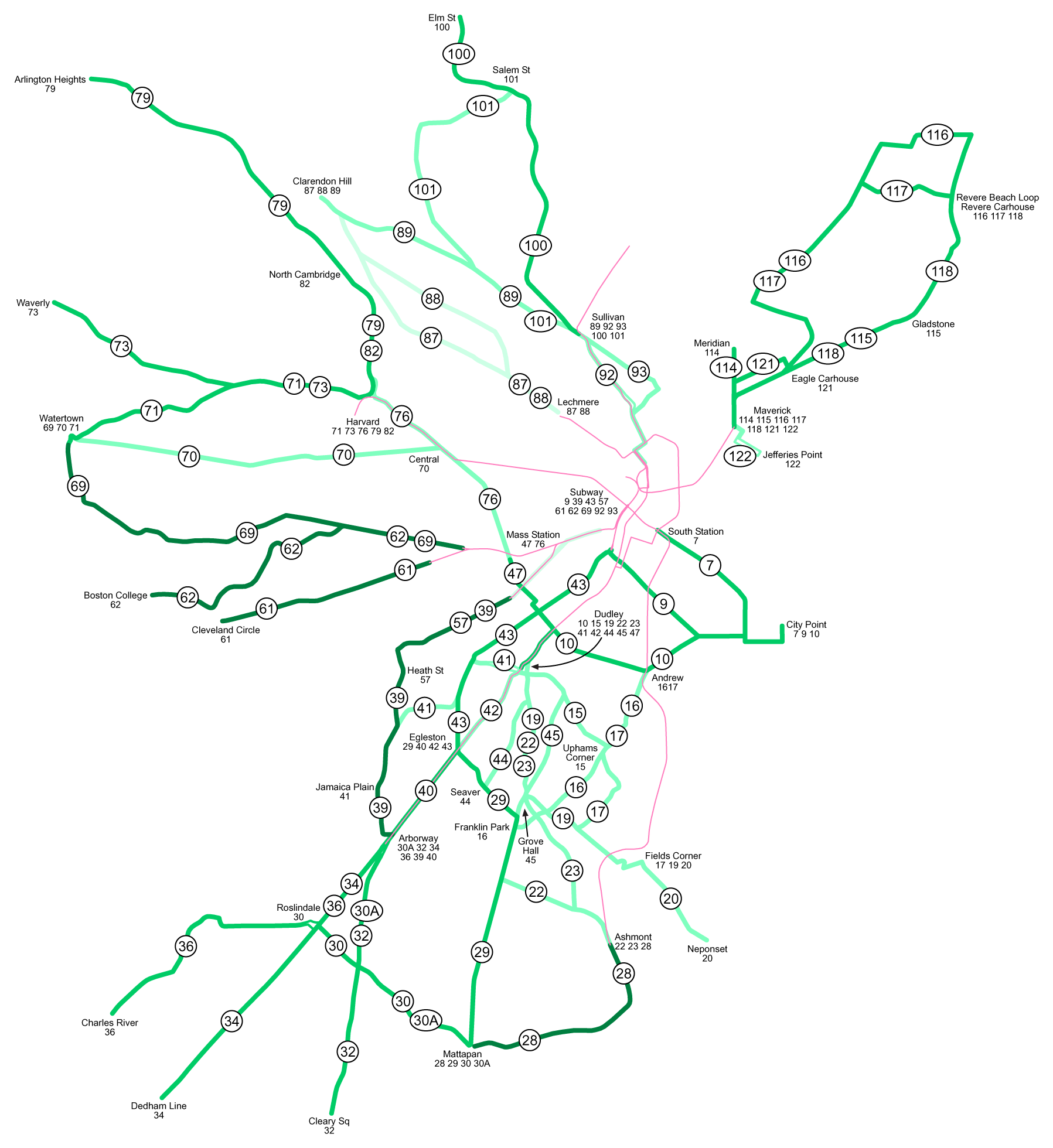
As generally understood by Bostonians, the T consists of four lines:
- The Green Line runs from a northern terminus in northeastern Cambridge south through downtown Boston in a tunnel and then splits into four surface-running branches that continue west into the city's near western suburbs of Newton and Brookline. Unlike the other lines, it runs light rail vehicles instead of rapid transit "subway" cars, and three of its four surface-running branches run in road medians with grade crossings.
- The Orange Line runs from a northern terminus in Malden south along a commuter rail line, continues south in a tunnel under downtown Boston, and then runs to its southern terminus in Jamaica Plain in southern boston via the same open cut as the Northeast Corridor.
- The Blue Line runs from downtown Boston east through a tunnel under Boston Harbor and then northeast in a surface right-of-way along the coast to Revere.
- The Red Line runs southwest in a subway through Cambridge and Boston from the northwest corner of Cambridge to Harvard Square, downtown Boston, and the northern part of the Dorchester neighborhood of Boston. It then splits into two branches, one that runs in a surface right-of-way to Ashmont in southern Boston and one that runs along a commuter rail line to Quincy and Braintree in the city's southern suburbs. At Ashmont, there is a change to the "Mattapan High-Speed Line", an eighty-year-old streetcar line running southwest in a private surface right-of-way to Mattapan on the southern border of Boston.
The Green Line
|
|
|
Streetcars in Boston
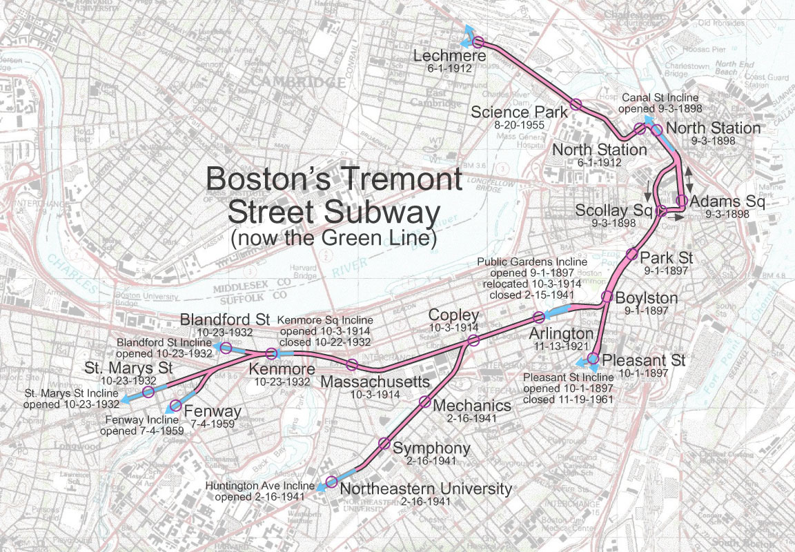
The MBTA likes to brag about the Green Line being the "oldest subway in America". This is a bit inaccurate: what was built in 1897 was a short tunnel to get cars from Boston's large streetcar network out of downtown traffic. While the original Tremont Street Tunnel from a portal at North Station to two portals: one at Tremont Street and Pleasant Street (now closed) and one along Boylston Street at the Public Garden was neither built as rapid transit nor to serve as a single coherent line, New York had built its first elevated rapid transit line two decades earlier.
In the Nineteenth Century, Boston had a large network of horse-pulled streetcars, as did many American cities. Rails allowed a horse to pull more and provide a smoother ride than a carriage or wagon, especially on unpaved roads. However, maintaining a large number of horses in a city was expensive, and contributed to one of the main pollution worries of the day: horse manure everywhere. In 1889, the West End Railroad, a company that had consolidated most of Boston's streetcar lines, started to convert them to electric power. Initially, they used a mixture of overhead wires and third-rail power in neighborhoods that objected to overhead wires, but third-rail power for streetcars was fairly quickly abandoned after several horses were electrocuted.
The Tremont Street Tunnel
Electrification was followed by the construction of the Tremont Street Tunnel by the Boston Elevated Railway (West End's successor) to avoid downtown traffic. There was no specific "Tremont Street Tunnel" service: most streetcar lines that ran downtown went through the tunnel, including the streetcar service to Cambridge across the Mass Ave bridge that eventually became the 1 bus. Streetcar lines down Cambridge St, Somerville Ave, and Highland Ave originally ran though the subway portal at Lechmere, but this through-running was discontinued in 1922.
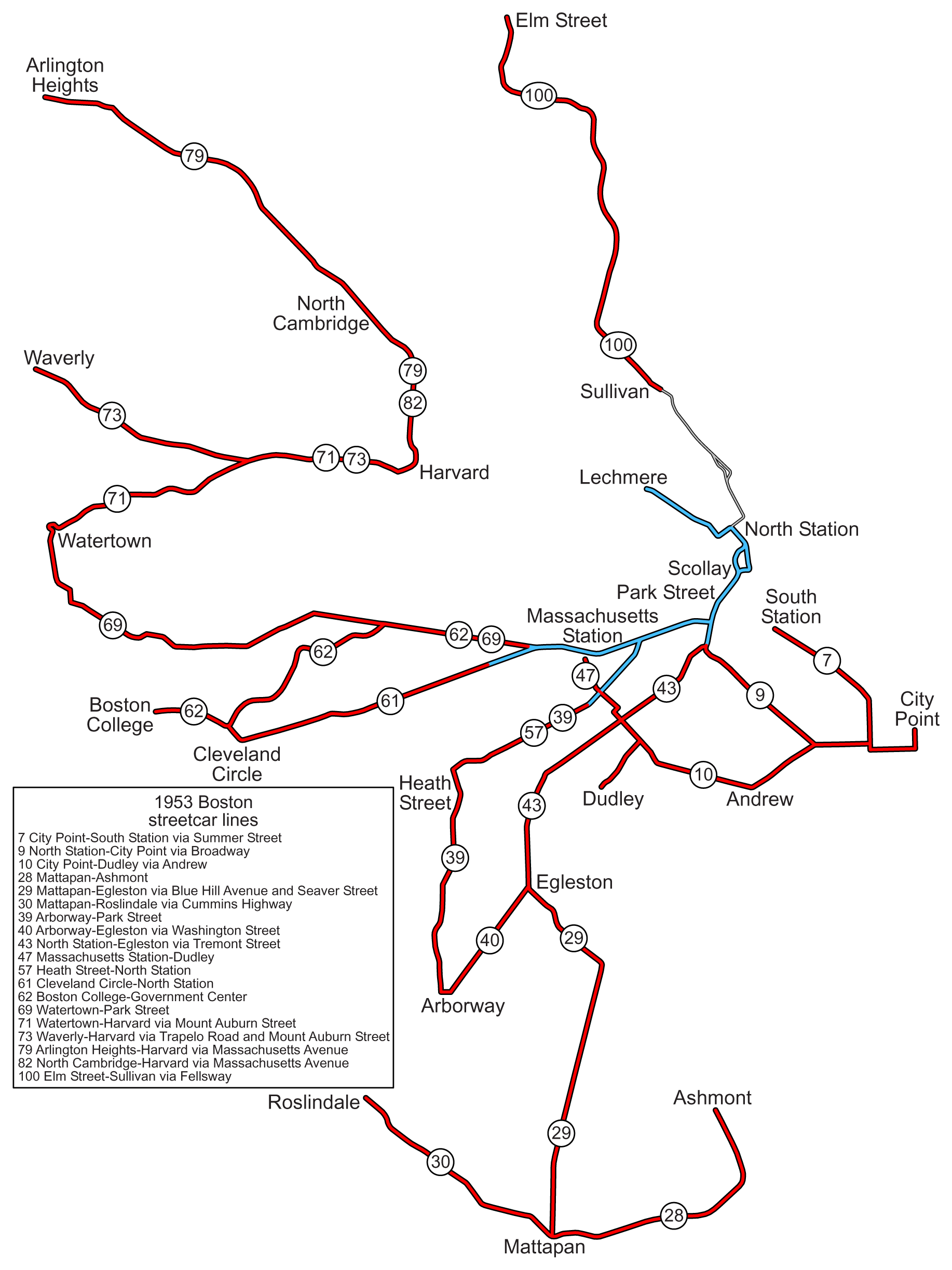
In the 1930s and 1940s, Boston's streetcar routes started to be replaced with buses, first in the suburbs and then in the city itself. By the mid-1950s, the only remaining streetcar lines were ones that had their own grade-separated rights-of-way for some of their routes, most of which used the Tremont Street subway.
Of course, by the 1950's, the grade-separated streetcar system that became the Green Line had expanded quite a bit. Near what is now Government Center, the tunnel fed into an elevated line to North Station in 1898 and across the Charles to Lechmere in 1912, where it served a number of Cambridge and Somerville streetcar lines. In 1914, the subway was continued under Boylston Street to Mass Ave, and in 1932 the underground station at Kenmore was built, along with the current portals for the B and C branches.
Kenmore is one of three four-track stations on the T (the others being Park and Boylston, though the tracks at Boylston leading to the southern half of the Tremont Street tunnel are not in use) because it was expected that the subway would be continued west along Commonwealth Ave. When the station was built, it was thought that the subway would eventually be used for rapid transit cars and the inner two tracks, from the Commonwealth Avenue portal, were built on pylons so they could eventually be lowered to accommodate high-platform rapid transit cars. Meanwhile, the outer two tracks, connected to the Boylston St portal, have a turn-around loop for the streetcars expected to continue to use this portal after the subway was converted.
In 1941, Boston's streetcar subway was still being extended: the Public Garden portal was closed and the subway under Huntington Ave from Copley to Symphony was built, with the portal supported on a wooden trestle in the expectation that the subway would eventually be expanded. The last new service added to the subway, though, was entirely grade-separated from the start. The Riverside Line (now called the D Branch of the Green Line) was originally part of the main line Boston and Albany Railway and served South Station. In the 1950's, as passenger railroad ridership was dying off, it was connected to the subway at Kenmore and converted to run streetcars.
The Modern Green Line
In 1958, the last streetcars (other than the Mattapan High-Speed Line) that didn't use the subway were replaced by buses, and in 1962, service ended on the southern branch of the original Tremont Street Subway, from Boylston to Pleasant Street. In 1967, the MBTA decided to rename its remaining rail lines (which had previously been assigned numbers, like buses) with colors, and the five remaining streetcar services extending west from the subway were assembled as the Green Line:
- A to Watertown along Commonwealth Ave and Beacon St.
- B to Boston College along Commonwealth Ave.
- C to Reservoir along Boylston St.
- D to Riverside along the old Boston and Albany right-of-way.
- E to Arborway/Forest Hills along Huntington Ave, Center St, and South St.
The Orange Line
The Main Line Elevated
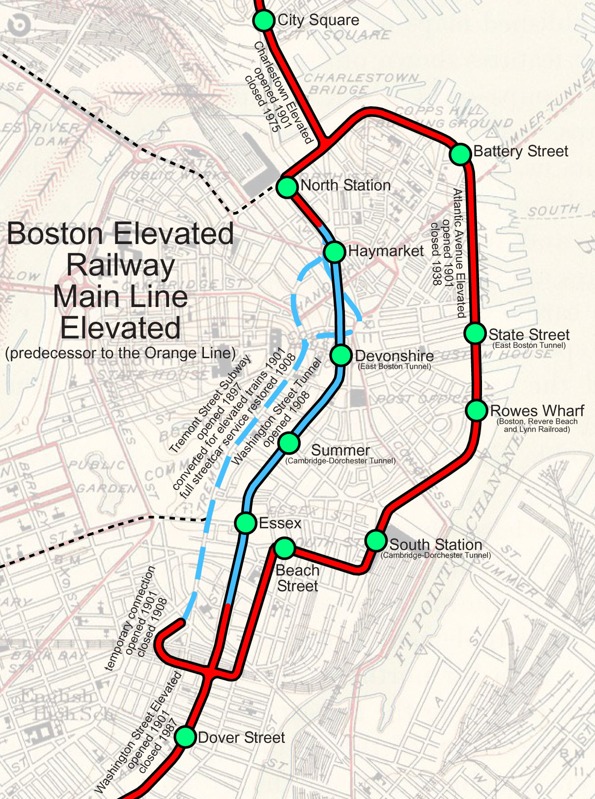
The Orange Line was the first of the T's lines to be built to provide rapid transit service and, unlike the other lines, it serves completely different track than when it opened. Although its first grade-separated project was the Tremont St streetcar tunnel, the Boston Elevated Railway's primary goal was to build a rapid transit line through Boston using high-platform, higher capacity "el cars" like those that had been in use in New York for years, rather than streetcars.
In 1901, the Boston Elevated Railway's "main line" opened from Dudley Square to Sullivan Square, following an elevated line through Charlestown, the Tremont Street Subway (each station had short high platforms added to serve the rapid transit cars), and an elevated line down Washington Street. A second route through downtown was provided by the Atlantic Avenue Elevated, which connected the Washington Street and Charlestown Elevateds with a route along the waterfront that connected South Station, the ferry terminals, and North Station.
In 1908, the current Orange Line tunnel under Washington St downtown was completed and rapid transit service in the Tremont Street Subway ended. The south end of the Washington Street Elevated was extended to Forest Hills in 1912 and the north end of the Charlestown Elevated was extended to Everett in 1919.
Demolishing the Els
However, relatively soon afterward, Boston began to tear down its elevateds. The Atlantic Avenue El was demolished first, in 1938, due to low ridership, particularly since there was no longer significant ferry service to the waterfront. This eliminated the one-seat ride between Boston's two major train terminals. The route from Everett through downtown to Dudley Square and Forest Hills, however, remained in 1967 when the MBTA renamed it the Orange Line. As the old elevated portions of the line were loud and shadowed major streets, there was a movement to replace them with non-elevated track. However, subway construction was considered too expensive, so the northern and southern ends of the line were instead relocated to commuter rail rights-of-way. In 1975, the Charlestown Elevated was torn down and rapid transit service to Everett ended. Instead, the line was extended north to Malden and Oak Grove, with an unused third track intended for potential express service if and when it is extended further north.
In the 1950s and 1960s, work was done to prepare the Northeast Corridor intercity and commuter rail embankment for conversion into an eight-lane highway called the "Southwest Corridor". When this project was killed due to opposition in the neighborhoods it went through, the land was instead converted into a park with three mainline rail tracks and two new Orange Line tracks, allowing the Washington Street Elevated to be demolished in 1987.
The loss of rapid transit service along Washington Street was a particular loss because Washington Street north of Dudley Square is the main transportation corridor into downtown from the south, as it follows the old Boston Neck, which used to have its south end at Dudley. A number of heavily used bus lines from southern Boston terminate at Dudley, which is the busiest bus station in the US without a rapid transit connection. The Silver Line bus lanes built on Washington Street were intended to serve as a replacement, but residents tended to consider them inadequate and derided the project as the "Silver Lie".
The Blue Line
The East Boston Tunnel
Like the Green Line, the Blue Line was originally constructed as a streetcar subway. In 1904, the East Boston Tunnel opened as the first under-ocean subway in the world, replacing ferry service that had previously connected East Boston's streetcar network to downtown. The line ran from Maverick to near Government Center and, like the Tremont Street Subway, carried streetcar lines that ran on the surface in East Boston. In 1925, though, ridership had become high enough that the tunnel was retrofitted for high-platform rapid transit cars powered by a third rail, with the East Boston streetcars terminating at Maverick for transfer to the tunnel service. The fact that the Blue Line's tunnel---and in particular, the turn-around-loop at Bowdoin---was originally built for streetcars constrains the line to use very short rapid transit cars, roughly the same length as that of Boston's streetcars, in order to have a small enough turning radius for some turns.
The Revere Extension
The East Boston Tunnel wasn't the first rapid transit service to East Boston, though. From 1875 to 1940, a narrow gauge railway called the Boston, Revere Beach, and Lynn Railroad ran from Lynn to a ferry terminal in East Boston. By the 1890's, it was providing steam-powered rapid-transit service service for commuters from Lynn, Revere, and Winthrop (where it had a branch line). In 1928, it was electrified, though this didn't prevent it from declining due to the Great Depression and the spread of cars.
After the railroad went bankrupt in 1940, Massachusetts bought up its right-of-way to Lynn for an extension of rapid transit service through the East Boston Tunnel. In 1952, service opened to the current terminus at Wonderland, though there are still vague plans to extend the line to Lynn, and the 1992 renovation of the commuter rail station there included provisions for a Blue Line station. The Blue Line is almost unique among rapid transit systems in the US that it uses both third rail and overhead power. The East Boston Tunnel, which was built for streetcars, isn't tall enough to allow for overhead wires along with taller rapid transit vehicles. On the other hand, third rail power along the beach in Revere would cause corrosion problems from the salt spray. As a result, Blue Line trains switch from third rail to overhead power while stopped at Airport.
The extension of the Blue Line to Revere also finally provided the Blue Line with its own storage and maintenance yard, at Orient Heights on the site of the old Boston, Revere Beach, and Lynn yard. Previously, cars needing maintenance had to be hauled up a portal at Bowdoin and along unpowered trolley tracks on Cambridge St to the Longfellow Bridge, where they could be run on the Red Line to its shops.
The Red Line
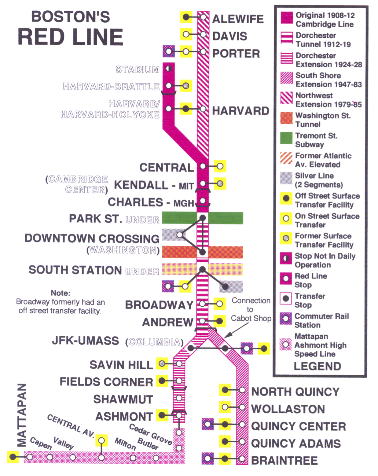
The Cambridge-Dorchester Tunnel
The Red Line was the last of the T's four lines to open, and it was designed with some of the lessons of the Main Line Elevated in mind. A fully underground route (other than the Charles River crossing that had been included in the Longfellow Bridge when it was constructed a decade earlier) was chosen to avoid the tight turns and noise complaints associated with elevateds. Furthermore, it was decided to break with the standard el-sized cars used on the Main Line Elevated and on early subways in New York City. Instead, higher-capacity ten-foot wide cars were used, a move that was later followed by the BMT subways under the Dual Contracts in New York and the Broad Street Subway in Philadelphia. While this did improve capacity, it also led to today's situation where each of the T's four lines uses incompatible rolling stock: light rail vehicles on the Green Line, el cars on the Orange Line, short el-width cars on the Blue Line because of its sharp turns, and wider cars on the Red Line.
The first part of the Red Line opened in 1912 from Harvard to Park Street, with a continuation to Andrew Square in Dorchester finished by 1918. The termini at Harvard and Andrew Square were chosen because they are major choke points in the road grid, where many streetcar lines came together, making them natural places for suburban commuters to transfer from streetcars to rapid transit. The terminal stations were designed with this in mind and were constructed with large streetcar stations as well as rapid transit platforms. Broadway, which was the southern terminus until Andrew Square opened, had a surface streetcar station for cars from South Boston and an underground station for cars from Dorchester, although the latter was closed after only two years, since the Dorchester streetcars terminated at Andrew Square soon after the station there opened. In fact, the Broadway station was so thoroughly designed with transfer passengers in mind that there was only a small, inconvenient entrance to the station for pedestrians. Andrew Square had a larger surface streetcar station above the subway platforms, which was eventually paved and is now used as a major bus station and transfer point.
Harvard Square
The terminus at Harvard Square was even more elaborate. The station was arranged in an east-west orientation under Mass Ave near Holyoke Gate, after which the tracks turned south under Brattle and Eliot Street before surfacing at a storage yard and repair shops on what is now the site of the Kennedy School of Government just north of Memorial Drive. A single-platform station called "Stadium" at the entrance to the yard was occasionally used for special events such as games the Harvard football stadium just across the Charles until the 1960s.
Just west of the Harvard station's platforms, a two-level streetcar tunnel from Mt. Auburn St to Mass Ave at the south end of Cambridge Common was built to serve as a transfer station and to allow streetcars to avoid the narrow and twisted streets around Harvard Square. Although the tunnel was eventually paved for trackless trolleys and, later, diesel buses, the last streetcar services in Boston (other than the Mattapan High-Speed Line) not to be part of the Green Line used the tunnel. Even today, the continued use of trackless trolleys on several bus routes that depart Harvard Square on Mt. Auburn Street is due to the MBTA's preference for using vehicles with left doors for bus routes that board in the southbound tunnel, where the platform is on the left of the roadway.
The Dorchester Extension
In 1928, the first extension of Boston's rapid transit network into an abandoned rail right-of-way occured, with the Dorchester Extension along the old Dorchester Branch of the Old Colony Railroad. The Dorchester branch ran to Mattapan Square on the Neponset River, but the last several miles of it crossed several bridges over the Neponset that weren't strong enough to support Red Line cars. To save money, it was decided to terminate the Red Line at Ashmont and to run a streetcar, the "Mattapan High-Speed Line" as a shuttle along the remainder of the rail right-of-way to Mattapan. Not only does this shuttle still exist today, but it forces the MBTA to maintain yet another incompatible form of rolling stock. It turns out that the bridges that couldn't support Red Line cars also can't support modern light rail vehicles, so 1940s-era PCC streetcars are still maintained for use on the line.
The Braintree Extension
When the Old Colony Railroad discontinued commuter rail service along its main line after a drawbridge fire in 1960, political will started to form for a Red Line branch to serve Quincy, which had previously been served by the Old Colony. The extension, which opened in 1971, branched off from the the Red Line just south of Andrew Square and ran express for four-and-a-half miles to North Quincy. It then provided relatively local service to Quincy Center. Since this service extends especially far from downtown Boston, and served as an express service replacing a commuter rail line, stations on this branch charged higher fares to enter and exit fares until the 2000s.
In the early 1980s, the line was extended to Braintree, its current terminus, and the opening of the UMass Boston campus near the JFK/UMass station (formerly called Columbia) led to a decision to add a stop on the Braintree branch, which had previously run express through the station. Since the Braintree Branch's tracks were both east of the Dorchester Branch's tracks, a second island platform was built for the Braintree Branch and the station lobby was rebuilt to extend over both track pairs.
The Northwest Extension
The final extension of the Red Line---and of the T in general---was the Northwest Extension from Harvard Square to Alewife. North from Harvard, a deep-bore subway extends to Davis Square, where cut-and-cover under an abandoned rail right-of-way is used to get to Alewife. From Alewife, the original plan was to extend the Red Line all the way to Lexington and Route 128 along the abandoned rail right-of-way that became the Minuteman Commuter Bikeway. However, opposition from residents of Arlington Heights scuttled this plan.
Connecting this extension to the tunnel at Harvard was a particularly complex engineering problem. Recall that the original station was built cut-and-cover in an east-west orientation with tracks turning south along Brattle St. The extension required trains to instead turn north. However, a very sharp turn was required, since the Harvard bus tunnel was built parallel to and very close to the north-south portion of Mass Ave and it was impossible to tunnel under the historic buildings of Harvard Yard. As a result, the Red Line makes a very sharp turn at low speed before reaching the new, north-south Harvard station's platforms.
During construction of the new Harvard station and the connection to the tunnel to Porter in the early 1980s, two temporary stations were built at Harvard. An inbound-only station whose platforms are still visible from inbound Red Line trains was built under Mass Ave just east of the original station. And a surface station was built at the north end of the old maintenance yard, just outside the portal at the south end of Brattle Street. Having the terminal station some distance outside the center of Harvard Square allowed easy transfer to buses that couldn't use the bus tunnel while it was being renovated as part of the construction of the new station.
As a final component of the work done in the 1980s, the older stations on the line had their platforms extended to allow longer trains. Evidence of this work can be seen in several places. The extensions to the Central and Kendall stations are slightly less ornate and are missing the central pillars that originally ran the full length of the stations. And the platform extension at Broadway curves slightly to account for a curve in the track in what used to be tunnel.